India is an enormous and very vast country full of incredible and mindblowing places, monuments, festivals, places, etc. India is blessed with many diverse natural resources from mountains, rivers, lakes, forests, caves, etc.
And obviously man-made marvels from largest forts, tallest towers, biggest railways network, longest tunnels, bridges, highways, etc.
Here is the list of known and unknown incredible facts and superlatives about the longest, largest, highest, and tallest in India.
Largest in India
1. Which is the Largest National Park in India?

Hemis National Park — Largest National Park in India
Located in the breathtaking cold desert region of Ladakh, Hemis National Park is the largest national park in India. It covers more than 4,400 square kilometers. Established in 1981, the park is famous for its rugged Himalayan landscapes, rare wildlife, and rich biodiversity.
It was named after the historic Hemis Monastery, one of the most important monasteries in Ladakh.
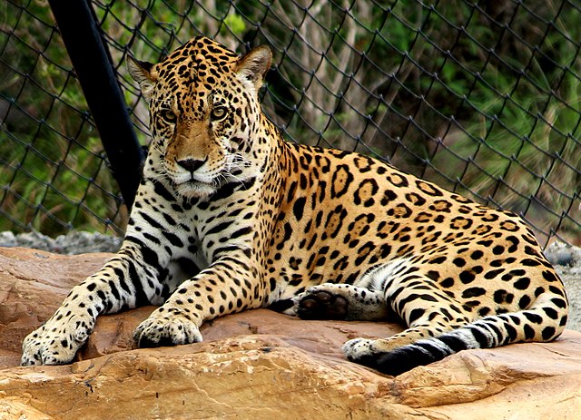
Hemis National Park is best known as one of the finest places in the world to spot the elusive snow leopard. The park is also home to several unique Himalayan species including the Tibetan wolf, Eurasian brown bear, the red fox, Argali (Great Tibetan Sheep), Bharal (Blue Sheep), Shapu (Ladakhi Urial), the Himalayan marmot, mountain weasel.
Quick Facts
| Detail | Information |
|---|---|
| Location | Ladakh |
| Area | 4,400 sq km |
| Established | 1981 |
| Famous For | Snow Leopards & Cold Desert Landscapes |
Why Is It Special?
- Largest national park in India
- Located in the high-altitude Himalayas
- Famous for snow leopard sightings
- Stunning cold desert scenery
💡Read Full Guide: Explore Hemis National Park – Wildlife, Best Time, Facts & Travel Guide
2. Which state has the Largest Forest Cover in India?
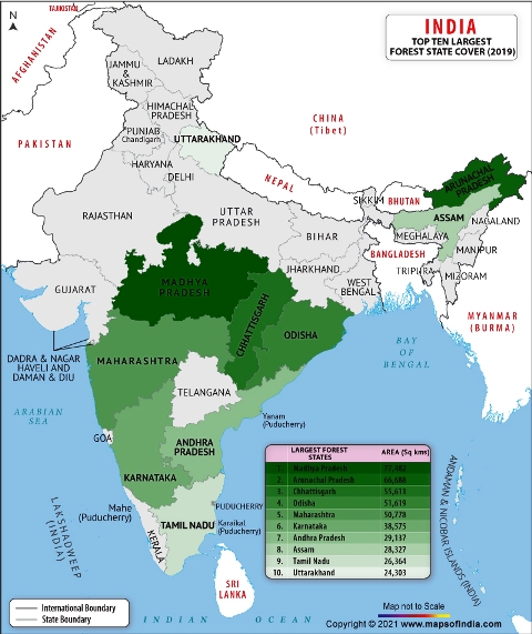
Madhya Pradesh has the Largest Forest Cover in India followed by Arunachal Pradesh, Chhattisgarh, Odisha, and Maharashtra.
In terms of forest cover as a percentage of total geographical area, the top five States are Mizoram (84.53%), Arunachal Pradesh (79.33%), Meghalaya (76.00%), Manipur (74.34%), and Nagaland (73.90%).
India’s overall forest and tree area is 80.9 million hectares, or 24.62 % of its geographic region, as per the India State of Forest Report 2021.
The forest area has increased by 1,540 square kilometers and tree cover has increased by 721 square kilometers in comparison to the previous report, ISFR 2021
3. Where is the Largest Zoo in India?
Sri Venkateswara Zoological Park is the largest zoo park in India. It is located in Tirupati, Andhra Pradesh.
It was established on 29 September 1987 and covers an area of 22.39 square kilometers.
Sri Venkateswara Zoological Park is also the largest zoological park in Asia.
It is followed by Arignar Anna Zoological Park or Vandalur Zoo in Chennai, Tamil Nadu, and Nandankanan Zoological Park in Bhubaneswar, Odisha.
The Thiruvananthapuram Zoo in Kerala is the oldest zoo in India. It is also the oldest in Asia.
The zoo and park were opened in 1859 and the museum was opened as early as September 1857.
HH Swathi Thirunal Rama Varma the ruler of Travancore was the visionary behind the establishment of the Thiruvananthapuram Museum and Zoo.
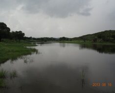
4. Which is the Largest Lake in India?
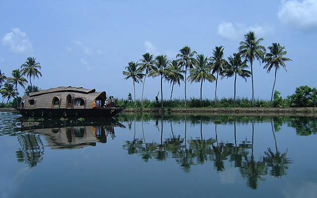
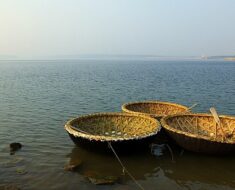
Vembanad Lake, also known as Vembanadu Lake, is the largest lake in India. Located in the state of Kerala, the lake covers an area of approximately 2,033 square kilometers, making it the biggest freshwater lake in the country.
Stretching across several districts of Kerala, Vembanad Lake is also the longest lake in India with a length of nearly 96.5 km.
The lake is an important part of Kerala’s famous backwaters and is known for its scenic beauty, houseboat cruises, wetlands, birdlife, and traditional village culture.
Vembanad Lake is spread across the districts of Alappuzha, Kottayam, Ernakulam, and Pathanamthitta. Interestingly, the lake is known by different local names in different regions, including:
- Vembanad Lake in Kottayam and Vaikom
- Punnamada Lake in Alappuzha
- Kochi Lake in Kochi
The lake also contains the second-largest wetland ecosystem in India after the Sundarbans of West Bengal and supports rich biodiversity, migratory birds, fishing communities, and agriculture in the Kuttanad region.
- Alleppey houseboat cruises
- Kumarakom Bird Sanctuary
- scenic Kerala backwaters
- and the annual Nehru Trophy Boat Race.
Read More: Largest Lake in India – The Vembanad Lake
5. What is the Largest River Island in India?
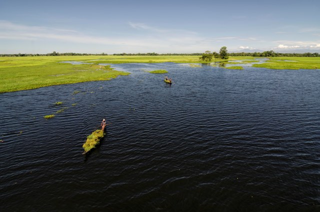
Majuli is the largest river island in India located in the Brahmaputra River in Assam. It is famous for its Assamese culture, Satras (monasteries), scenic landscapes, and river island villages.
Quick Facts About Majuli
| Detail | Information |
|---|---|
| Location | Assam |
| River | Brahmaputra River |
| Type | River Island |
| Current Area | Approx. 352 sq km |
| Former Area | Approx. 1,255 sq km |
| Famous For | Assamese Neo-Vaishnavite Culture |
| District Status | Became India’s first island district in 2016 |
| Nearest City | Jorhat |
| UNESCO Status | Tentative World Heritage Site |
Why is Majuli Famous?
- Scenic ferry rides across Brahmaputra River
- Largest inhabited river island in India
- Famous for Satras and Assamese culture
- Known for traditional mask-making art
- Rich biodiversity and migratory birds
Read More: Deepest River in India – The Brahmaputra
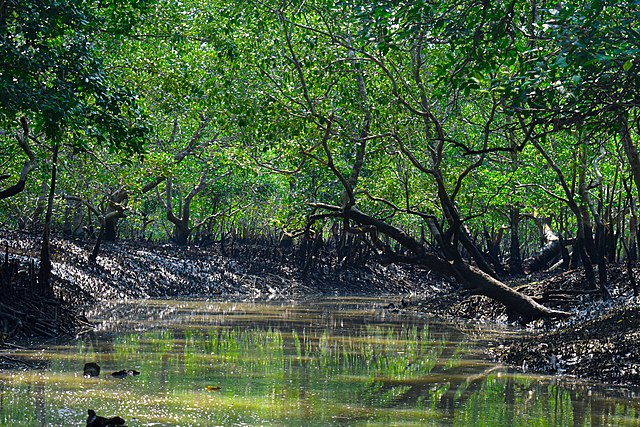
6. Which is the Largest Wetland in India?
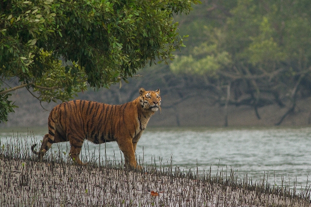
The Sundarbans are the Largest Wetland in India. It is formed by the confluence of the Padma (the Ganga in India), Brahmaputra, and Meghna Rivers in the Bay of Bengal.
Its area spans from the Baleswar River in Bangladesh, Khulna to the Hooghly River in India, West Bengal.
It is located within the largest mangrove forest in the world.
The Indian Sundarban, covering the southwesternmost part of the delta, constitutes over 60% of the country’s total mangrove forest area and includes 90% of Indian mangrove species.
Sundarbans National Park was declared a UNESCO World Heritage Site in 1987.
It has been designated as a Ramsar site since 2019.
7. Which is the Largest Delta in India?
The Ganges Delta is the largest delta in India. It is also known as the Sundarbans Delta or the Bengal Delta.
The Sundarbans Delta is the also world’s largest river delta. It stretches from the Hooghly River east as far as the Meghna River and mostly lies in Bangladesh and India
The Ganges delta is also one of the most fertile regions in the world, thus nickname the Green Delta.
It has the shape of a triangle and is considered an arc-shaped delta that covers more than 105,000 km2 (41,000 sq mi).
8. Which is the largest Artificial Island in India?
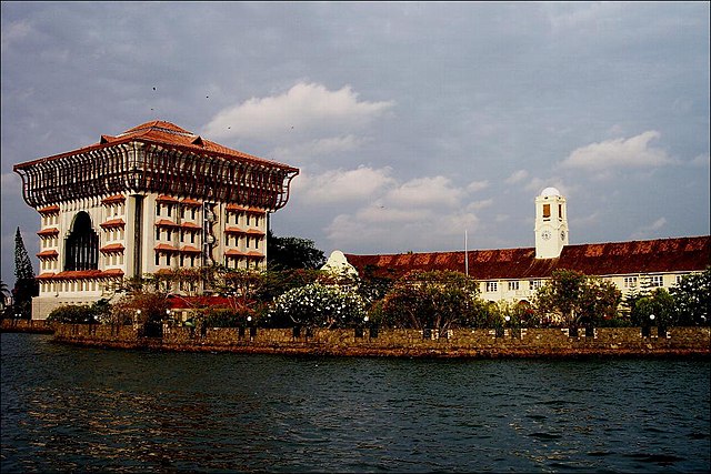
Willingdon Island is the largest artificial island in India. It is in the city of Kochi, Kerala.
Most of the present Willingdon Island was claimed from the Lake of Kochi by filling in dredged soil around a previously existing natural island.
The idea of developing a new port in Kochi was first felt by Sir Robert Bristow. He was appointed by Lord Willingdon the then Governor of Madras Presidency to create a new modern port.
The island was created during the construction of a modern port in 1936 and was completed in 1939. Sir Robert Bristow owned the first building on the island
Willingdon Island is significant as the home for the Port of Kochi as well as the Kochi Naval Base, the Southern Naval Command of the Indian Navy, Plant Quarantine Station, Customs House Cochin, and Central Institute of Fisheries Technology, a constituent unit of the Indian Council of Agricultural Research.
9. Which is the Largest Dam in India?
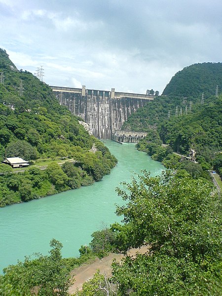
The Bhakra Nangal Dam is the largest dam in India. It is located in the state of Himachal Pradesh and Punjab.
Situated on the Sutlej river it is the largest dam in India having a height of 225 meters. It also holds the second position in the largest dams all over Asia.
The Bhakra Nangal Dam has the third largest reservoir in India in terms of quantity of water,
The first is the Indira Sagar dam in Madhya Pradesh and the second Nagarjunasagar Dam in Andhra Pradesh and Telangana
Read More: Shortest River in India – The Arvari River
10. Which is the Largest Solar Park in India?
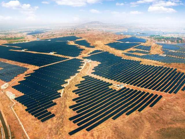
Bhadla Solar Park is the largest solar park in India and in the world as well. It is spread over a total area of 5,700 hectares (14,000 acres) in Bhadla, Jodhpur, Rajasthan.
At its full operational capacity, the Bhadla Solar Park became the largest fully commissioned PV project in the world at 2,245 MW.
Pavagada Solar Park solar park stands in the second position in India, covering an area of 13,000 acres in Pavagada taluk, Tumkur district, Karnataka.
It was completed in 2019 and the solar park has a capacity of 2,050 MW. (Link)
11. Which is the Largest Windmill Farm in India?
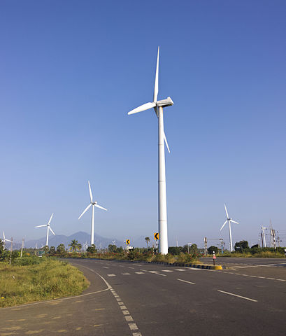
Muppandal Wind Farm is the Largest Windmill Farm in India. Located in Kanyakumari, Tamil Nadu, the farm has a capacity of 1500MW
Developed by Tamil Nadu Energy Development Agency It has an installed capacity is 1,500 MW, which makes it the 3rd-largest operational onshore wind farm in the world.
The Jaisalmer Wind Park is India’s second-largest and globally the fourth-largest operational onshore wind farm. It is located in the Jaisalmer district of Rajasthan
| Wind Power Plant | Megawatt (MW) | Location |
| Muppandal Wind Farm | 1500 | Tamil Nadu, Kanyakumari |
| Jaisalmer Wind Park | 1064 | Rajasthan, Jaisalmer |
| Brahmanvel Wind Farm | 528 | Maharashtra, Dhule |
| Dhalgaon Wind Farm | 278 | Maharashtra, Sangli |
| Vankusawade Wind Park | 259 | Maharashtra, Satara District. |
| Vaspet | 144 | Maharashtra, Vaspet |
| Tuljapur | 126 | Maharashtra, Osmanabad |
| Beluguppa Wind Park | 100.8 | Beluguppa, Andhra Pradesh |
| Mamatkheda Wind Park | 100.5 | Madhya Pradesh, Mamatkheda |
| Anantapur Wind Park | 100 | Andhra Pradesh, Nimbagallu |
12. Which is the Largest Hindu Temple in India?

Sri Ranganathaswamy Temple in Srirangam, Tamil Nadu, is the largest Hindu temple in India and also one of the largest functioning Hindu temples in the world.
Dedicated to Lord Ranganatha, a reclining form of भगवान Vishnu, the temple is one of the most important pilgrimage sites for Vaishnavites and is among the sacred 108 Divya Desams.
Quick Facts About Sri Ranganathaswamy Temple
| Detail | Information |
|---|---|
| Location | Srirangam, Tiruchirappalli, Tamil Nadu |
| Dedicated To | Lord Ranganatha (Vishnu) |
| Temple Area | 155 acres |
| Architectural Style | Dravidian / Hindu Architecture |
| Total Towers | 21 Gopurams |
| Shrines | 81 Shrines |
| Pavilions | 39 Mandapams |
| Famous For | Largest Functioning Hindu Temple |
| Sacred Status | One of the 108 Divya Desams |
Why is Sri Ranganathaswamy Temple Famous?
- Largest Hindu temple complex in India
- One of the world’s largest functioning temples
- Dedicated to Lord Vishnu
- Famous for massive Dravidian architecture
- Enclosed by seven concentric walls called Prakarams
- Important pilgrimage site for Vaishnavites
The temple complex is enclosed by seven massive concentric walls known as Prakarams, whose combined length exceeds 32,000 feet (over six miles).
Read More: Largest Hindu Temple in India – Sri Ranganatha Swamy Temple
13. Where is the Largest Temple Tank in India?

Haridra Nadhi is the largest temple tank in India and also the largest tank among all of the Hindu temples.
The Haridra Nadhi temple tank belongs to Rajagopalaswamy Temple, Mannargudi, Thiruvarur, Tamil Nadu. The temple is called Dakshina Dwarka (Southern Dwarka) along with Guruvayoor by Hindus.
The Rajagopalaswamy temple is a Vaishnava temple of the main god Rajagopalaswamy (Krishna).
The Haridra Nadhi tank is at the entrance of the shrine where rainwater is collected. It was constructed by Kulothunga Chola I. And later renovated by the Later Cholas and the Thanjavur Nayaks.
Read More: Oldest Hindu Temple – Mundeshwari Devi Temple
14. Which is the Largest Fort in India?
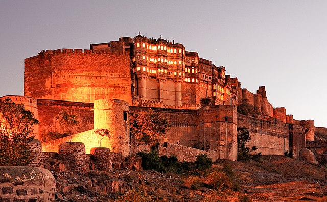
Mehrangarh Fort in Jodhpur, Rajasthan, is considered one of the largest and most magnificent forts in India. Built atop a rocky hill around 122 meters above the surrounding plains, the massive fort complex spreads across nearly 1,200 acres (486 hectares).
The fort was constructed in 1459 by Rao Jodha, the Rajput ruler of the Rathore clan and founder of Jodhpur.
The name Mehrangarh translates to “Fort of the Sun,” reflecting the Rathore dynasty’s mythical descent from the Sun God Surya.
Quick Facts About Mehrangarh Fort
| Detail | Information |
|---|---|
| Location | Jodhpur, Rajasthan |
| Built By | Rao Jodha |
| Built In | 1459 |
| Area | Approx. 1,200 acres |
| Elevation | 122 meters above city |
| Architectural Style | Rajput Architecture |
| Famous For | Massive Fort Walls & Blue City Views |
| Popular Attractions | Palaces, Museums, Temples, Cannon Terraces |
Why is Mehrangarh Fort Famous?
- Offers panoramic sunset views of Jodhpur
- One of the largest forts in India
- Massive hilltop fort overlooking Jodhpur’s Blue City
- Famous for Rajput architecture and royal palaces
- Home to museums, temples, and historic gates
- Popular filming location for Hollywood & Bollywood movies
Read More: Mehrangarh Fort Jodhpur – History, Architecture & Travel Guide
15. What is the Largest Museum in India?
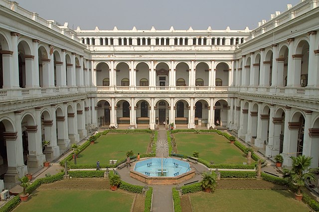
The Indian Museum in Central Kolkata, West Bengal is the largest Museum in India.
The Museum is also referred to as the Imperial Museum at Calcutta in colonial-era texts.
The Indian Museum is the ninth oldest museum in the world and the oldest and largest museum in India.
It has rare collections of antiques, armour and ornaments, fossils, skeletons, mummies, and Mughal paintings.
It was founded by the Asiatic Society of Bengal in Kolkata, India in 1814.
Read More: 15 Must-Visit Historical Places in India
Longest in India
1. Which is the Longest Railway Tunnel in India?
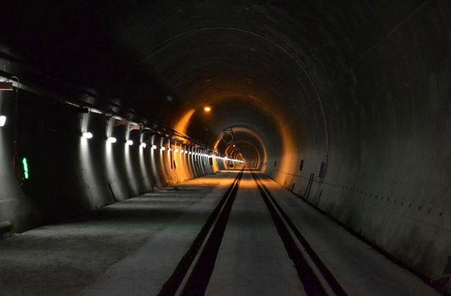
Pir Panjal Railway Tunnel is the longest railway in India. The length of the tunnel is 11.215 km between Quazigund and Banihal in Jammu and Kashmir.
It is a part of the Jammu–Baramulla railway line.
The 11.55 km long rail tunnel number 12 is under construction between Senapati and Imphal West districts on Jiribam–Imphal railway line.
Once completed it will surpass Pir Panjal Railway Tunnel and will become India’s Longest Railway Tunnel.
Although Indian Railway has plans to construct the Patalpani rail tunnel in Madhya Pradesh.
It is expected to be complete by 2025, this tunnel will become India’s longest railway tunnel with a whooping 49 km in length.
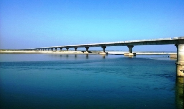
2. Which is the Longest Railway Bridge in India?
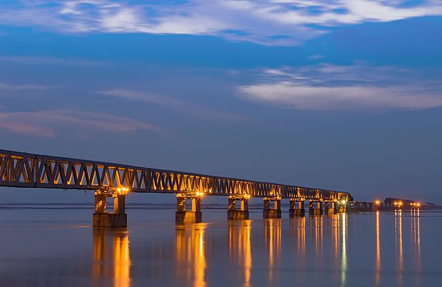
Bogibeel Bridge in Assam is the longest railway bridge in India. Built across the mighty Brahmaputra River, it is India’s longest rail-cum-road bridge and one of the most important infrastructure projects in Northeast India.
The bridge connects the districts of Dibrugarh and Dhemaji in Assam and significantly improves road and railway connectivity in the region.
Quick Facts About Bogibeel Bridge
| Detail | Information |
|---|---|
| Location | Assam |
| River | Brahmaputra River |
| Length | 4.94 km |
| Type | Rail-cum-Road Bridge |
| Connects | Dibrugarh & Dhemaji |
| Construction Started | 2002 |
| Inaugurated | 25 December 2018 |
| Inaugurated By | Prime Minister Narendra Modi |
| Special Feature | India’s first fully welded steel-concrete rail bridge |
| Earthquake Resistance | Can withstand earthquakes up to magnitude 7 |
Why is Bogibeel Bridge Famous?
- Longest railway bridge in India
- India’s longest rail-cum-road bridge
- Asia’s second-longest rail-cum-road bridge
- Built over the Brahmaputra River
- Has a double railway track on the lower deck
- Features a three-lane road on the upper deck
- Designed for a service life of around 120 years
The bridge was constructed by a consortium led by Hindustan Construction Company and took nearly 200 months to complete.
Second Longest Railway Bridge in India
The Vembanad Rail Bridge in Kerala is the second-longest railway bridge in India with a total length of approximately 4.62 km.
It connects Edappally and Vallarpadam in Kochi and is primarily used for freight railway services.
Read More: Longest Railway Bridge in India – Bogibeel Bridge
3. Which is the Longest Railway Platform in India?
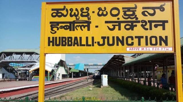
Hubbali Junction is the longest railway platform in India with a length of 1,400 meters (4,600 ft). It is also the world’s longest railway station platform.
Previously Gorakhpur railway station was the longest railway platform in India. It has a length of 1366 meters.
It remained the longest railway platform in the world from October 2013 until surpassed by the Hubbali Junction Railway Platform.
4. Which is the Longest Dam in India?
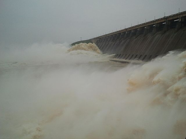
Hirakud Dam is the longest dam in India. It is located in the state of Orissa and has a total length of 25.79 km.
Situated on the river Mahanadi about 15 km from Sambalpur, Odisha. It also features in the list of the longest dams in the world.
It is one of the first major multipurpose river valley projects that started after India’s independence.
Sir Hawthorne Lewis, the Governor of Odisha laid the foundation stone of the Hirakud Dam on 15 March 1946.
Pandit Jawaharlal Nehru laid the first batch of concrete on 12 April 1948.
The dam was completed in 1953 and was formally inaugurated by Prime Minister Jawaharlal Nehru on 13 January 1957. Power generation along with agricultural irrigation started in 1956, achieving full potential in 1966
Hirakud Dam has been declared a Ramsar site in August 2022.
Read More: Ganga of South India- The Dakshin Ganga | The Godavari River
5. Which is Longest Traveling Train in India?
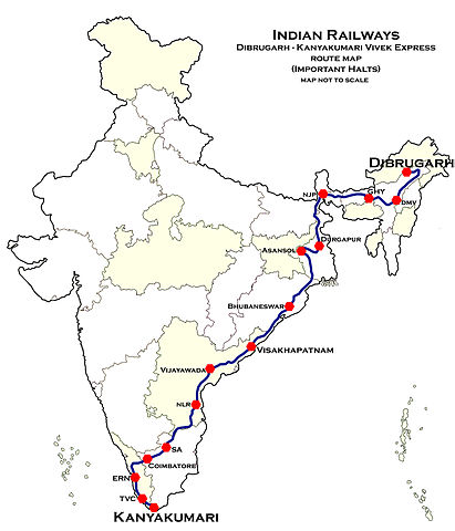
Vivek Express from Dibrugarh in Assam to Kanyakumari in Tamil Nadu is the longest Traveling Train in India.
The train route between Dibrugarh to Kanyakumari is the longest train route in the Indian Railways network.
It covers a total distance of 4218.6 km traveling through 8 states with 58 intermediate stoppages. And takes almost 74 hours and 35 minutes to reach its destination.
It is the 24th-longest train service in the world.
Vivek Express are four pairs of Express Trains on the Indian Railways network. These trains were started to commemorate the 150th birth anniversary of Swami Vivekananda.
These trains were announced by the then Railway Minister Mamata Banerjee in the Railway Budget of 2011-12.
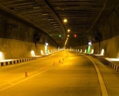
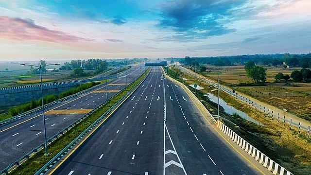
6. What is the Longest Road Tunnel in India?

The Chenani–Nashri Tunnel, officially known as the Dr. Syama Prasad Mookerjee Tunnel, is the longest road tunnel in India. Located on National Highway 44 in Jammu and Kashmir, the tunnel has a total length of 9.028 km.
The construction of the tunnel began in 2011 and was completed in 2017. It is also regarded as Asia’s longest bi-directional highway tunnel.
The tunnel significantly improves connectivity between Jammu and Srinagar by reducing travel distance by nearly 30 km and cutting travel time by around two hours.
Quick Facts About Chenani–Nashri Tunnel
| Detail | Information |
|---|---|
| Official Name | Dr. Syama Prasad Mookerjee Tunnel |
| Common Name | Chenani–Nashri Tunnel |
| Location | Jammu & Kashmir |
| Highway | NH 44 |
| Length | 9.028 km |
| Construction Started | 2011 |
| Opened In | 2017 |
| Famous For | Longest Road Tunnel in India |
| Special Feature | Fully Integrated Tunnel Control System |
Why is Chenani–Nashri Tunnel Famous?
- Longest road tunnel in India
- Asia’s longest bi-directional highway tunnel
- Reduces Jammu–Srinagar travel time by nearly 2 hours
- Helps avoid avalanche-prone mountain roads
- India’s first tunnel with a fully integrated control system
The tunnel bypasses snowfall-prone regions like Kud, Patnitop, and Batote, which earlier caused heavy traffic congestion and road closures during winters.
Atal Tunnel – Another Engineering Marvel
The Atal Tunnel, also known as the Rohtang Tunnel, is one of India’s most famous highway tunnels located in Himachal Pradesh on the Leh–Manali Highway.
Although slightly shorter than the Chenani–Nashri Tunnel, the Atal Tunnel holds a world record as the longest highway tunnel above 10,000 feet in the world.
Quick Facts About Atal Tunnel
| Detail | Information |
|---|---|
| Location | Himachal Pradesh |
| Highway | Leh–Manali Highway |
| Length | 9.02 km |
| Elevation | Above 10,000 feet |
| Built Under | Rohtang Pass |
| Opened In | 2020 |
| World Record | Longest Highway Tunnel Above 10,000 Feet |
The Atal Tunnel was officially recognized by the World Book of Records in 2022 for its remarkable engineering achievement.
Read More: Longest Road Tunnel in India – Chenani Nashri Tunnel Guide
7. Which is the Longest Road Bridge in India?
The Bhupen Hazarika Setu, popularly known as the Dhola Sadiya Bridge, is the longest road bridge in India above water. Located in Assam, the bridge stretches across the mighty Lohit River, a major tributary of the Brahmaputra River.
Built to improve connectivity in Northeast India, the bridge connects the states of Assam and Arunachal Pradesh and serves as the first permanent road link between northern Assam and eastern Arunachal Pradesh.
Quick Facts About Bhupen Hazarika Setu
| Feature | Details |
|---|---|
| Location | Assam & Arunachal Pradesh |
| Common Name | Dhola Sadiya Bridge |
| Length | 9.15 km |
| River | Lohit River |
| Opened In | 2017 |
| Named After | Dr. Bhupen Hazarika |
| Importance | Longest road bridge above water in India |
The bridge significantly reduced travel time between the two states and also plays a crucial role in transportation, tourism, and defense connectivity in the strategically important Northeast region.
Why Is Bhupen Hazarika Setu Important?
The bridge is considered one of India’s most important infrastructure projects in the Northeast because it:
- improves connectivity between remote regions,
- reduces travel time by several hours,
- boosts tourism and trade,
- supports military movement near the Indo-China border,
- and enhances economic development in Arunachal Pradesh.
The bridge was inaugurated in 2017 and named after the legendary Assamese singer and cultural icon Dr. Bhupen Hazarika.
Second Longest Road Bridge in India
The Dibang River Bridge in Arunachal Pradesh is currently the second-longest road bridge above water in India.
It connects Dambuk and Roing in eastern Arunachal Pradesh and has a total length of approximately 6.2 km.
Upcoming Longest Road Bridge in India
The Kacchi Dargah–Bidupur Bridge in Bihar is currently under construction and is expected to become the longest road bridge in India after completion.
Quick Facts
| Feature | Details |
|---|---|
| Location | Bihar |
| Expected Length | 9.76 km |
| Connects | Patna and Hajipur |
| River | Ganga River |
| Status | Under Construction |
Once completed, the bridge will surpass the Bhupen Hazarika Setu in total length.
Read More: Longest Road Bridge in India – Bhupen Hazarika Setu
8. Which is the Longest Expressway in India?
The Purvanchal Expressway is the longest Expressway in India. Developed by Uttar Pradesh Expressways Industrial Development Authority (UPEIDA).
The Purvanchal expressway connects Chand Saray village near Gosainganj in Lucknow district with Haydaria village on NH-31 in Ghazipur district and is 6-lane wide (expandable to 8).
It has a 3.2 km long airstrip at Akhalkiri Karwat village in Sultanpur district for emergency landing of aircraft. 6-lane wide (expandable to 8)
Agra Lucknow Expressway is the second longest expressway in India. It has a length of 302.2 km and connects the cities of Agra and Lucknow.
The Delhi–Meerut Expressway with 14 lanes is the widest expressway in India.
Under construction Delhi–Mumbai Expressway which will connect India’s national capital New Delhi with its financial capital Mumbai will surpass the Purvanchal Expressway once completed.
The Delhi–Mumbai Expressway has a length of 1350 km and is 8-lane wide (expandable to 12-lane) and is expected to be complete by March 2023.
It will become India’s longest and busiest expressway.
9. Which is the Longest National Highway in India?
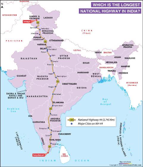
National Highway 44 is the longest national highway in India. It has a total length of 3745 km, starting from Srinagar in the north and ending in Kanyakumari in the south.
National Highway 44 (NH 44) was previously known as National Highway 7.
The NH44 come into being by merging seven major national highways of old numbers that include NH 1A, NH 1, NH 2, NH 3, NH 75, NH 26, and NH 7.
10. Which is the Longest Wall in India?
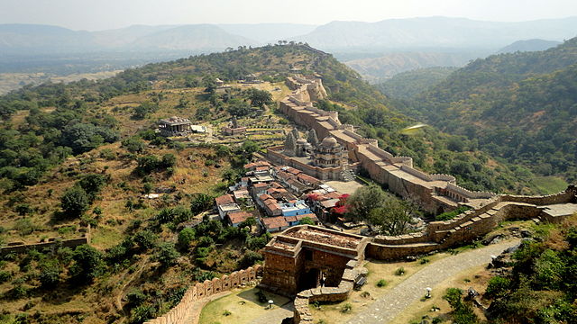
The Great Wall of Kumbhalgarh Fort in Rajasthan is the longest wall in India. It is also known as the Great wall of India and second longest wall in the world.
The Kumbhalgarh fort was built by Rana Kumbha in the 15th century and the fort is among the largest fort complexes in the world. It is spread to an area of 662 acres (268 ha)
The chief architect who built this fort was Mandan, who documented his style of work in his text, Rajvallabh.
The Kumbhalgarh fort is built on a hilltop at a height of 1,100 m on the westerly range of Aravalli Hills.
It is about 48 km from Rajsamand city in Rajasthan and about 84 km from Udaipur.
The fort has a perimeter of walls that extends up to 36 km and the frontal walls are fifteen feet thick.
The Kumbhalgarh fort has seven fortified gateways. There are over 70 temples within the fort, both Jain and Hindu Temples.
In 2013 it was declared a UNESCO World Heritage Site under the group Hill Forts of Rajasthan.
Read More: Qutub Minar – Tallest Brick Minar in the World
11. Which one is the Longest Beach in India?
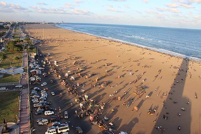
Marina Beach is the longest beach in India. Situated in Chennai it has a length of 13 km which includes 6 km of the seafront.
It is the longest natural urban beach in India and the second longest in the world after Cox’s Bazar Beach in Bangladesh.
The beach runs from near Fort St. George in the north to Foreshore Estate in the south, Chennai along the Bay of Bengal.
It was renovated by Governor Mountstuart Elphinstone Grant Duff in the 1880s.
12. Where is the Longest Cave in India?
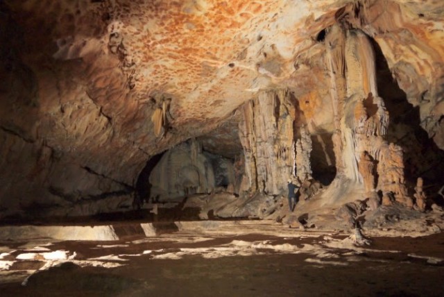
Krem Liat Prah Meghalaya is the longest natural cave in India.
The Krem Liat Prah in the Jaintia Hills is 30,957 m (101,600 ft) long. The word “Krem” means Cave in the local Khasi language.
The Caves of Meghalaya comprise a large number of caves in the Jaintia, Khasi Hills, and Garo Hills districts in Meghalaya.
These Caves in Meghalaya are not only the longest in India but also among the longest caves in the world.
Out of the top ten longest caves in India, the first nine caves are in Meghalaya and the tenth is in Mizoram.
There is an annual caving expedition organized by Meghalaya Adventurers Association (MAA) and is known as the “Caving in the Abode of the Clouds Project”.
13. Which is the Longest Canal in India?
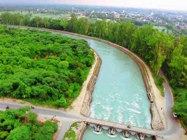
The Indira Gandhi Canal is the longest canal in India and has a total length of 605 km.
It starts at the Harike Barrage in Punjab and ends in irrigation facilities in the Thar Desert in northwest Rajasthan.
The canal was renamed the Indira Gandhi Canal on 2 November 1984 following the assassination of Prime Minister Indira Gandhi. Earlier it was known as the Rajasthan Canal.
After the construction of the Indira Gandhi Canal, irrigation facilities were available over an area of 6,770 km2 (1,670,000 acres) in Jaisalmer district and 37 km2 (9,100 acres) in Barmer district.
14. Which is the Longest River in India?
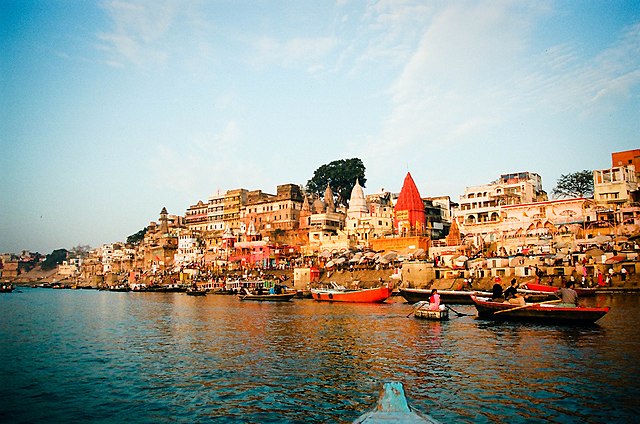
The Ganga River, also known as the Ganges, is the longest river in India and one of the most sacred rivers in Hinduism. Originating from the Gangotri Glacier in the Himalayas, the river flows across northern India before entering Bangladesh and finally emptying into the Bay of Bengal.
The Ganga is not only the longest river in India but also the largest river system in the country, followed by the Godavari River.
Quick Facts About the Ganga River
| Feature | Details |
|---|---|
| River Name | Ganga (Ganges) |
| Length | 2,525 km |
| Source | Gangotri Glacier, Uttarakhand |
| Mouth | Bay of Bengal |
| States Covered | Uttarakhand, Uttar Pradesh, Bihar, West Bengal |
| Countries | India & Bangladesh |
| Largest Tributary System | In India |
Origin of the Ganga River
The main channel of the Ganga officially begins at Devprayag, where the Alaknanda River and Bhagirathi River meet in Uttarakhand.
The river then flows through the fertile plains of North India and supports millions of people through agriculture, transportation, and religious tourism.
Why Is the Ganga River Important?
The Ganga holds immense cultural, spiritual, and economic importance in India because it:
- is considered the holiest river in Hinduism,
- supports one of the world’s most densely populated river basins,
- provides water for agriculture and daily life,
- is home to diverse wildlife including the endangered Ganges river dolphin,
- and plays a major role in Indian history and civilization.
Read More:
15. Which State has the Longest Coastline in India?
Gujarat state has the longest coastline in India. It has a coastline of 1214.7 km followed by Andhra Pradesh with 973.7 km.
Andaman and Nicobar Islands have the longest coastline in India among the Indian Islands.
Indian Union Territory of Damn and Diu has the shortest coastline of 42.5 km.
India has a coastline of about 7,516.6 km bordering the mainland and the islands with the Bay of Bengal in the East, the Indian Ocean in the South, and the Arabian Sea in the West
Length of the Coastline of India
| State/UT | Length (in Km) |
| Gujarat | 1214.7 |
| Andhra Pradesh | 973.7 |
| Tamil Nadu | 906.9 |
| Maharashtra | 652.6 |
| Kerala | 569.7 |
| Odisha | 476.4 |
| Karnataka | 280 |
| West Bengal | 157.5 |
| Goa | 101 |
| Andaman & Nicobar Islands | 1962 |
| Lakshadweep | 132 |
| Puducherry | 47.6 |
| Daman & Diu | 42.5 |
Highest in India
1. Which is the Highest Lake in India?
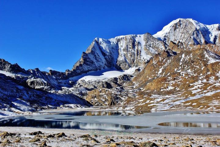
Tso Lhamo Lake or Cholamu lake is the highest lake in India. Located in Sikkim it is at an altitude of 6,200 m (20,300 ft)
It is one of the highest lakes in the world, situated just about 4 km southwest of the international border with China in North Sikkim
The Tso Lhamo Lake is a fresh-water glacial lake located northeast of the Kangchenjunga range.
The source of the lake is the water from the Zemu glacier, Kangtse glacier (or Pauhunri glacier) and it is the source of the Teesta River.
The Gurudongmar Lake is the second highest lake in India located at a height of 5,430 m (17,800 ft). The lake lies just 5 km to the west of the Tso Lhamo Lake.
It is also a fresh-water glacial lake that along with the Tso Lahmu forms the source of the Teesta River.
The Gurudongmar Lake remains completely frozen in the winter months, from November to Mid-May.
The lake is considered sacred by Buddhists, Sikhs, and Hindus.
It is named after Guru Padmasambhava also known as Guru Rinpoche the founder of Tibetan Buddhism.
Read More: Golden Temple, Amritsar – Four Doors To Heaven
2. Which is the Highest Waterfall in India?
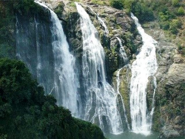
Kunchikal Falls — Highest Waterfall in India
Located in the lush Western Ghats of Karnataka, Kunchikal Falls is the highest waterfall in India with an impressive height of 455 meters (1,493 ft). The waterfall is situated in the Shimoga district inside the dense Agumbe rainforest, one of the wettest regions in India.
Formed by the Varahi River, Kunchikal Falls is known for its breathtaking multi-tiered cascade and untouched natural beauty. Surrounded by thick forests and mist-covered hills, the waterfall remains one of the hidden natural wonders of India.
Quick Facts
| Detail | Information |
|---|---|
| Location | Shimoga District, Karnataka |
| Height | 455 meters |
| River | Varahi River |
| Famous For | Highest Waterfall in India |
| Region | Western Ghats |
Other Tallest Waterfalls in India
- Barehipani Falls (Odisha) – 399 meters
- Nohkalikai Falls (Meghalaya) – 340 meters
- Dudhsagar Falls (Goa) – 310 meters
Nohkalikai Falls is also famous for being the tallest plunge waterfall in India.
Why Is Kunchikal Falls Special?
- Highest waterfall in India
- Located inside the Agumbe rainforest
- Surrounded by the biodiversity-rich Western Ghats
- One of India’s lesser-known natural wonders
💡Read Full Guide: Explore Kunchikal Falls – Travel Guide, Facts & Best Time to Visit
3. What is the Highest Mountain in India?
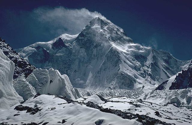
K2 or Mount Godwin-Austen is the Highest Mountain in India. It is also known by the nicknames The King of Mountains and The Mountaineers’ Mountain.
K2 has a height of 8,611 meters (28,251 ft) above sea level and is the second-highest mountain on Earth, after Mount Everest (8,848 m)
It lies in the Karakoram range partially in the Gilgit-Baltistan (Pakistan-occupied Kashmir) region and partially in a China-administered territory of India
Kanchenjungha is the second highest mountain and highest peak in India. It is located at the border of Sikkim and Nepal.
It is the third highest mountain in the world.
Kangchenjunga, also spelled Kanchenjunga and Khangchendzonga has a height of 8598m (28,169ft) above sea level.
It was assumed to be the highest mountain in the world until 1852.
But calculations and measurements by the Great Trigonometrical Survey of India in 1849 showed that Mount Everest, known as Peak XV at the time, is actually higher.
In 1856 it was officially announced that Kangchenjunga was the third highest mountain
Khangchendzonga National Park was declared a UNESCO World Heritage Site in 2016
4. Which is the Highest Dam in India?

The Tehri Dam is the highest Dam in India. It is located in Tehri Garhwal district in the state of Uttarakhand.
The dam is situated on the river Bhagirathi and has a height of 260.5 meters. It stands 12th in the list of highest dams in the world.
The Tehri Dam is a multi-purpose rock and earth-fill embankment dam with a total planned installed capacity of 2400 MW.
It is the biggest Hydroelectric power plant in India.
Read More: Cleanest River in India – The Umngot River
5. Which is the Highest Gateway in India?
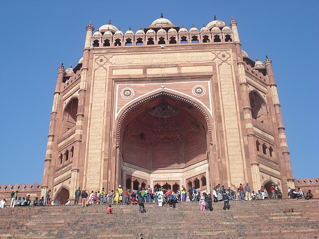
Buland Darwaza (Door of Victory) is located at Fatehpur Sikri in Agra and is the Highest Gateway in India.
It was built by Mughal Emperor Akbar to celebrate his victory over Gujarat. It displays the elegance, sophistication, and heights of technology in Akbar’s empire.
Buland Darwaza is the main entrance to the Jama Masjid at Fatehpur Sikri, which is 43 km from Agra.
It was not a part of the original design of the Jama Masjid but it was erected to celebrate his conquest of Gujarat. Verses from the Quran have been carved in the Naskh (script) along the top.
6. Which is the Highest Speed Train in India?
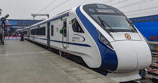
The Gatimaan Express is currently the highest-speed train in India and has a top speed of 160 km/h.
The fastest train as of 2022 in India is the Vande Bharat Express which has a top speed of 180 km/h (110 mph). But the Gatimaan Express is the fastest operating train with a top operating speed of 160 km/h (99 mph).
The first high-speed railway corridor of length 508 km is currently under construction between Mumbai and Ahmedabad. It will have a top operational speed of 320 km/h (200 mph).
The Indian Railways is currently improving their existing conventional railway lines to handle speeds up to 180 km/h (110 mph).
7. Which is Highest Railway Bridge in India?
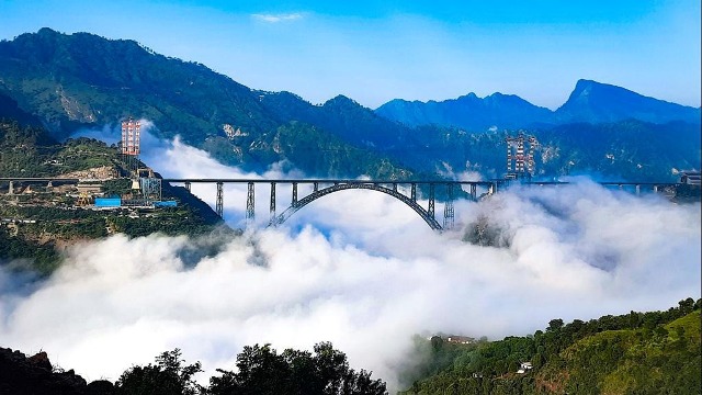
The Chenab Rail Bridge is the highest railway bridge in India. It is built over the Chenab river in the Reasi district of Jammu and Kashmir.
The rail bridge has a height of 359 m (1,178 ft) and is also the Highest Rail Bridge in the World.
The Chenab Rail Bridge connects Bakkal and Kauri, Reasi. The rail bridge is a steel and concrete arch bridge.
The bridge was fully completed and was inaugurated in August 2022. It is expected to open to rail traffic in December 2022.
8. Which is the Highest Railway Station in India?

The Ghum Railway Station of the Darjeeling Himalayan Railways is the highest railway station in India.
The railway station is situated at an altitude of 2,258 meters (7,407 ft).
The construction of the Darjeeling Himalayan Railway started in 1879 and the railway track reached Ghum on 4 April 1881.
The journey from Kolkata to Darjeeling used to take 5–6 days until 1878, using steam-engine-pulled trains.
Siliguri was put on the railway map of India in 1878 and shortening the journey to two days.
9. Which is the highest motorable Road in India?
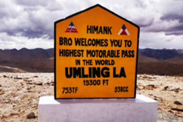
The Umling La Pass in Ladakh is the highest motorable road in India as well as the highest motorable road in the world. Situated at an elevation of 5,798 meters (19,024 feet) above sea level, the pass connects the remote villages of Chisumle and Demchok near the Indo-China border.
The road was constructed by the Border Roads Organisation (BRO) under Project HIMANK, which is responsible for building and maintaining roads in Ladakh and other high-altitude border regions.
Quick Facts About Umling La Pass
| Feature | Details |
|---|---|
| Location | Ladakh |
| Elevation | 5,798 m (19,024 ft) |
| Record | Highest motorable road in the world |
| Connects | Chisumle and Demchok |
| Constructed By | Border Roads Organisation (BRO) |
Umling La overtook famous Himalayan passes like Dungri La and Khardung La to achieve the record for the world’s highest motorable road.
Project HIMANK of the BRO also maintains several other strategic high-altitude roads including:
- Khardung La
- Chang La
- Tanglang La
These roads provide crucial connectivity to sensitive military regions such as:
- Siachen Glacier
- Pangong Tso Lake
- Line of Actual Control (LAC)
The construction and maintenance of roads in Ladakh are extremely challenging due to heavy snowfall, freezing temperatures, landslides, and low oxygen levels at high altitudes.
Read More: Umling La – Highest Motorable Road in the World
10. Which is the Highest airport in India?
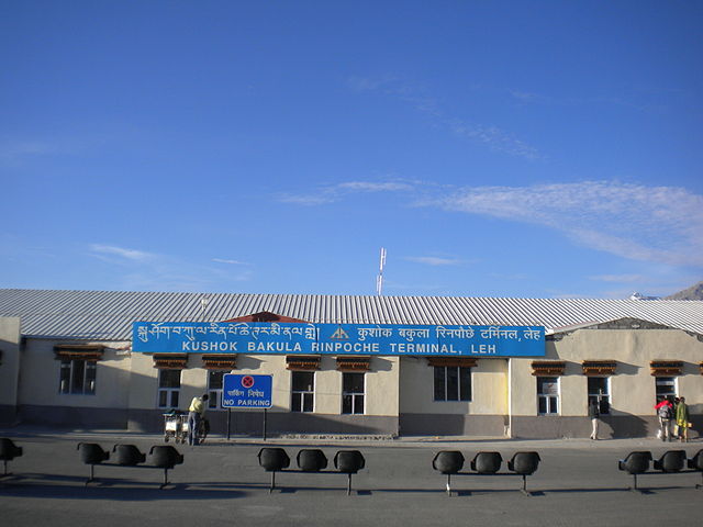
Kushok Bakula Rimpochee Airport is the highest airport in India. The airport is located in Leh at a height of 3,256 m (10,682 ft) above mean sea level.
The airport is named after Ngawang Lobzang Thupstan Chognor commonly known as 19th Kushok Bakula Rinpoche.
He was an Indian statesman, and monk, whose Spituk Monastery is in the direct vicinity of the airfield. He also served as India’s ambassador to Mongolia.
11. Which is the Highest Battle Field in India?
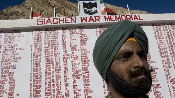
The Siachen Glacier is the highest battlefield in India as well as the highest battlefield in the world. Located in the eastern Karakoram Range of the Himalayas, the glacier lies at an altitude of around 5,753 meters (18,875 feet) above sea level.
Often referred to as the “world’s highest battleground,” Siachen is one of the most extreme and inhospitable military zones on Earth, where soldiers face freezing temperatures, avalanches, and harsh climatic conditions throughout the year.
Quick Facts About Siachen Glacier
| Feature | Details |
|---|---|
| Location | Karakoram Range, Ladakh |
| Altitude | 5,753 m (18,875 ft) |
| Length | Approximately 76 km |
| Record | Highest battlefield in the world |
| Controlled By | India |
| Military Presence Since | 1984 |
The Siachen Glacier is the longest glacier in the Karakoram Range and the second-longest glacier in the world outside the polar regions.
Why Is Siachen Important?
Siachen holds immense strategic importance for India because it overlooks key mountain passes and borders near Pakistan and China.
India has maintained control over the glacier and the major passes of the region since Operation Meghdoot in 1984. Pakistan controls areas west of the Saltoro Ridge, which lies away from the main glacier.
The glacier remains one of the toughest military postings in the world, where survival itself is considered a challenge due to:
- temperatures dropping below -50°C,
- avalanches and snowstorms,
- low oxygen levels,
- and difficult mountainous terrain.
Many soldiers stationed here lose their lives due to extreme weather conditions rather than direct combat.
Siachen stands as a symbol of the courage, endurance, and sacrifice of the Indian Armed Forces guarding the country in one of the harshest environments on Earth.
Read More: Siachen Glacier – The Highest Battle Ground on Earth
12. Which place gets the Highest Rainfall in India?
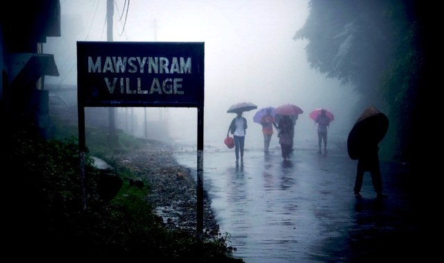
Mawsynram is the place with the highest rainfall in India. It is a small town in the East Khasi Hills district of Meghalaya, the northeastern part of India.
It is reportedly the wettest place on Earth, with an average annual rainfall of 11,872 millimeters.
Mawsynram received 26,000 millimeters (1,000 in) of rainfall in 1985 which is a world record and recorded in the Guinness Book of World Records.
Cherrapunji had occupied the position of the highest rainfall in India and the world also for a significant amount of time. But recent observations have revealed that it is Mawsynram that receives the maximum amount of annual rainfall.
Mawsynram is just located 15 km west of Cherrapunji.